
Services
LEADER IN LiDAR IMAGING
SERVICES

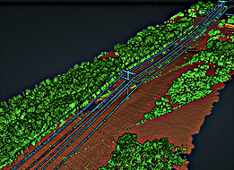
LIDAR SURVEY
Mobile and Aerial LiDAR survey, and processing. DEM, Hydro Flattening, DTM, Contour, As-built model, CAD Contours, PLS-CADD, Vegetation, Rail, Pipeline, and more.

PHOTOGRAMMETRY
Unmanned photogrammetry services. We take pride in high accuracy ortho products, including DSM, DTM, Ortho, slope models, contour, and high-density point clouds.

INSPECTION
Our experience partnering with utility providers allows us to be ready to deliver high quality imagery and motion video of your vital assets.

ABOUT
Aerial Insight Services is a pioneer of unmanned surveying, mapping, and inspection. Our world-wide team has collected high-quality and business transforming data in the United States, Latin America, and APAC.
We have relationships with the largest drone and sensor manufacturers around the world to bring you the best technology to your project.
Our team of specialists have mastered the art of data acquisition. We are a professional and integral part of your team. We will always deliver the best in resolution, accuracy, and response time.
1,000+
Missions
Flown
400 sqkm
Largest
Ortho
30,000+
Inspection Images


INDIANA DRONES
CONTACT
Inquiries
For any inquiries, questions or commendations, please call: (720) 248-8667 or fill out the following form
Contact Us
Head Office
Satellite Office
2120 University Ave
Berkeley, CA 94704
Get a quote: 720-248-8667